
Despite it's name which suggests a viewer, GPX Viewer is a very capable mobile app for navigation, route following and track recording. It is reliable, provides a useful set of features and a nice set of maps that are visually pleasing and useful for hiking. It comes in two versions on Android, the basic free version and the paid Pro version. On iOS it comes only as a paid version.
In this article we will review the Android Pro version, since it comes with a couple of important features that are not available in the free one:
- offline maps
- track recording
The Android Pro version is available for a one-time payment of around 8.50 USD, which in our opinion is well worth the price for a very handy offline navigation app.
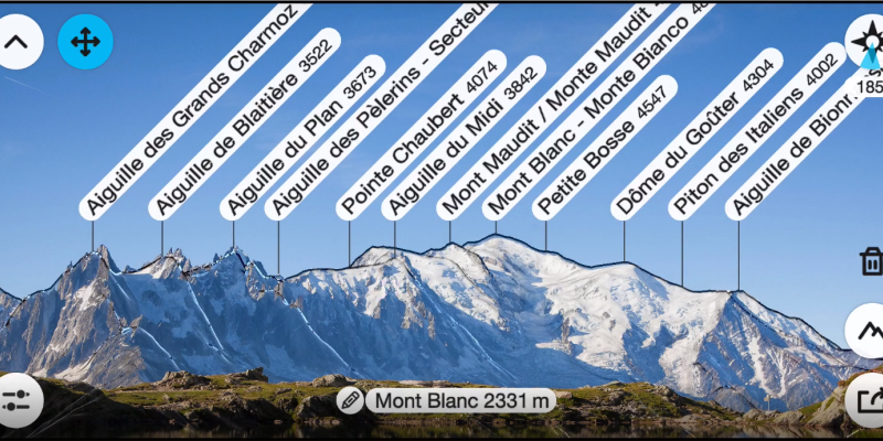
PeakFinder is an app designed to help users identify mountains and peaks in their surroundings. The app uses augmented reality technology, the GPS receiver and built-in sensors of your mobile device to overlay information about the names and elevations of mountain peaks onto the camera view.
AGPS-TrackerOm is an interesting Android application. It's main function is to follow preloaded tracks and record your tracks, and tries to do so reliably - ensuring that the GPS data is recorded at all times, even when the phone goes into stand-by mode. It can also provide enhanced accuracy of your current elevation, by using altitudes from NASA-generated Digital Elevation Models (DEMs) instead of the GPS-provided elevation which can be quite inaccurate.
AGPS-TrackerOm (previously called A-GPS Tracker++), differs from the lighter version, A-GPS Tracker in the following:
- AGPS-TrackerOm uses offline maps maintained by OpenStreetMap, which you need to preload. The "lighter" A-GPS Tracker uses Google maps which are not available offline.
- You can download Digital Elevation Models (DEM) which allow the app to display altitude contour lines and provide DEM altitude along with GPS altitude, the former being more accurate